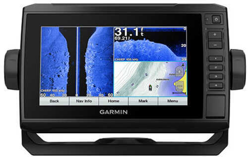
Garmin International ECHOMAP Plus 73sv with GT52 Transducer
Step up your angling with the Garmin® ECHOMAP™ Plus 73sv with GT52 Transducer Fish Finder/Chartplotter Combo. Its bright, sunlight-readable 7", keyed-assist touchscreen display provides crisp, vivid presentation of several data sources. The preloaded LakeVu g3 maps include integrated Navionics® data to cover more than 17,000 lakes, with up to 1' contours. Built-in Quickdraw Contours mapping software instantly creates personalized fishing maps on-screen with 1' contours, in real time, as you fish. Use built-in Wi-Fi® to pair with the free ActiveCaptain™ app for access to OneChart™, smart notifications, Garmin Quickdraw™ Community data, and more. Share waypoints and routes with other ECHOMAP or STRIKER units. Unlike ordinary fish finders and chart plotters, the Garmin ECHOMAP Plus 73sv with GT52 Transducer Finder/Chartplotter Combo provides NMEA 2000 support for engine data, sensors, FUSION-LINK™ audio system, autopilots and more. Includes GT52 transducer for Garmin high wide CHIRP traditional sonar plus CHIRP ClearVü and CHIRP SideVü scanning sonars, and compatibility with Panoptix™ all-seeing sonar (sold separately); and mount for transom or trolling motor.
Features :
- Bright, sunlight-readable, 7" keyed-assist touchscreen display
- Preloaded LakeVü g3 maps with integrated Navionics data
- More than 17,000 lakes, with up to 1' contours
- Built-in Quickdraw Contours real-time mapping
- Built-in Wi-Fi for free ActiveCaptain app, or access to OneChart, smart notifications, Garmin Quickdraw Community data, and more
- Share waypoints and routes with other ECHOMAP or STRIKER™ units
- NMEA 2000 support for engine data, sensors, FUSION-LINK audio system, autopilots, and more
Package Includes :
- ECHOMAP Plus 73sv with LakeVü g3 for U.S.
- GT52HW-TM Transducer
- Power/Data Cable
- Tilt/Swivel Mount with Quick Release Cradle
- FlushMmount
- Protective Cover
- Hardware
- Documentation
Specifications :
General :
- Dimensions: 9.80" x 5.50" x 2"
- Display Size: 6.10" x 3.40" and 7" Diagonal
- Display Resolution: 400 x 800 Pixels
- Display Type: WVGA Display
- Weight: 1.70 lbs
- Water Rating: IPX7
- Power Consumption: 15W
- Antenna: Internal or External Over NMEA 2000
- Mounting options: Bail or Flush
- Receiver: 5 Hz
- Garmin Marine Network Ports: 1 Panoptix
Maps and Memory :
- Preloaded Maps: LakeVü g3 (Inland Maps)
- Accepts Data Cards: 1 microSD Card (32GB Maximum)
- Waypoints: 5,000
- Routes: 100
- Track Log: 50,000 Points and 50 Saved Tracks
Outdoor Recreation Features :
- Tide Tables
Chartplotter Features :
- Garmin Sonar Compatible
- Supports AIS (Tracks Target Ships Position)
- Supports DSC (Displays Position Data From DSC-Capable VHF Radio)
- Supports FUSION-Link Compatible Radios
Sonar Features and Specifications :
- Dual Frequency (50/200 kHz) Sonar Capable
- Dual Beam (77/200 kHz) Sonar Capable
- T